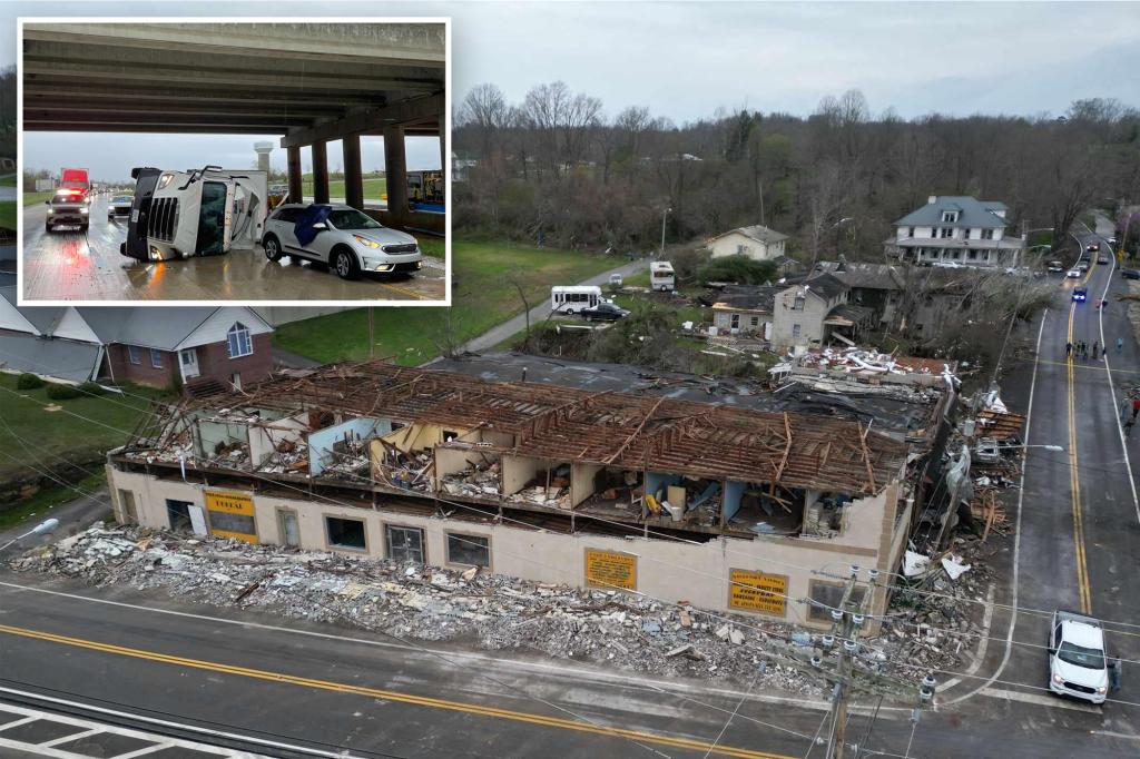
After storms caused damage in the nation’s heartland Monday, Tuesday’s severe weather outbreak produced hundreds of reports of damaging winds, large hail and tornadoes.
The first round of severe thunderstorms caused damage across the Ohio Valley during the morning, only to be followed by discrete supercells during the late afternoon and evening.
The hardest-hit communities appeared to be along the Ohio River, where damage was reported to trees, power lines and buildings.
Following the storm system, PowerOutage.us reported more than 250,000 electrical outages, with many in West Virginia.
Ohio Valley hit by severe storms Tuesday, causing injuries
Early Tuesday morning, an 84-mph wind gust was reported near Evansville, Indiana. City officials reported significant storm damage throughout the city, particularly on the north side.
In nearby Vanderburgh, Indiana, damage was caused to the city’s Emergency Operations Center’s roof. According to the National Weather Service, multiple instances of downed trees, power lines and damage to mobile homes were reported throughout the city.
Additional strong winds and falling trees caused notable destruction in southern Boonville, Indiana, leading to roof and structural damage. Utility poles were also snapped in Chrisney, Indiana, due to the high winds.
Emergency managers reported one person suffered minor injuries in Uniontown, Kentucky, when a tree fell onto a mobile home, according to the NWS office in Paducah, Kentucky.
The states of Ohio and West Virginia experienced significant damage to various structures, causing widespread tree and power line damage.
The Proctorville, Ohio, Fire Department building was destroyed, and several other structures suffered significant damage. Multiple structures in South Point, Ohio, were damaged, and there was widespread tree and power line damage. In Hanging Rock, Ohio, several trailers were flipped over.
On Tuesday morning, there was a wind gust of 92 mph near Huntington, West Virginia, and a reported wind gust of 102 mph in Boyd County, Kentucky.
These winds caused trees and power lines to fall and damaged several homes.
The governors of Kentucky and West Virginia issued states of emergency ahead of the worst of the weather.
Jeff Diederich, sheriff of Williamson County in Illinois, said a significant amount of property damage was reported in the county early Tuesday. He said the damage included downed trees and power lines.
“We have residences that have significant trees across their roofs,” Diederich told FOX Weather. “We have roofs that are missing in some isolated residential areas and then we have multiple businesses that are significantly damaged or completely destroyed.
During the severe weather, several vehicles along Interstate 265 in southern Indiana outside of Louisville, Kentucky, were flipped during strong winds. Westbound lanes were blocked by the overturned vehicles as emergency crews responded to the scene.
Louisville Mayor Craig Greenberg announced a local state of emergency for Jefferson County, Kentucky, due to thousands of power outages, but no injuries were reported from the storms.
Tornadoes reported in Georgia, Alabama
A powerful line of tornado-warned storms swept through Georgia overnight Tuesday, leaving damage in its wake and thousands without power early Wednesday morning.
According to storm reports logged by the NWS and NOAA’s Storm Prediction Center, a possible tornado struck Rockdale County in Georgia just before midnight, leaving trees down at several locations along Hurst Road.
Dozens of roads were reported to be impassable with trees and power lines down, according to FOX 5 in Atlanta. Emergency officials urged people who did not need to travel to stay home until conditions became safer. Additionally, there were reports of another possible tornado in Conyers, Georgia, overnight Tuesday, with power lines and trees down throughout the area.
About 200 miles to the southwest, multiple structures were damaged, and trees were down and uprooted along multiple county roads in Chilton, Alabama, where there were three more reports of possible tornadoes around midnight, according to the NWS.


